The Interactive NSW Research Map showcases the state's higher education, science, and research and development facilities in an easy-to-use geospatial format.
The map is a 'one-stop shop' for information about:
- the state's 11 universities under NSW Acts, including their campuses and university designated research centres, with additional information about other public and private universities with campuses in NSW
- Australian Research Council (ARC) Centres of Excellence which are headquartered or have a presence in NSW
- ARC Industrial Transformation Research Program research hubs and training centres based in NSW
- Cooperative Research Centres, including those headquartered or that have nodes in NSW
- publicly funded research agencies (PFRA), and some of the laboratories of PFRAs, including the Australian Nuclear Science and Technology Organisation (ANSTO) and the Commonwealth Scientific and Industrial Research Organisation (CSIRO)
- NSW Government agencies which are involved in science-related activities
- NSW Government institutions, including museums, park and zoos, which undertake research activities
- medical research institutes and centres, including those established as part of a university, as well as NSW Government-run health and medical research hubs
- critical research infrastructure, including National Collaborative Research Infrastructure Strategy (NCRIS) projects
- industrial, technology and business parks.
Users can search for research centres or infrastructure by Organisation Type and/or Field of Research (FOR). Download details of the 22 FOR categories and their sub-categories [PDF - 75KB].
The Interactive NSW Research Map will not only enhance the profile of the State's universities and research centres, it will undoubtedly prove a useful tool for the development of research, industry and international collaborations.
Tips for Use
The minimum supported web browsers for the map are Internet Explorer 10, Firefox 38.0, Chrome Version 41, or Safari 5.
Sifting through the extensive database of more than 650 NSW research organisations is easy.
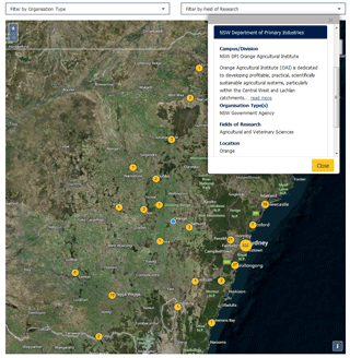
Simply select one or more 'Organisation Type' and/or 'Field of Research' from the drop down boxes above the map to filter the organisations. You can simultaneously select and unselect entries on both drop down menus.
If you want to see a university's 'campuses' or 'statewide research presence', under the 'Organisation Type' menu select 'Universities', and then those options for one or more of the listed universities.
The presence of a research centre/organisation is marked on the map with a yellow circle. The number in the circle indicates how many research centres/organisations are located at that location.
Clicking on a yellow circle will generate a pop-up box containing information about the organisation/s. Clicking on the name of the organisation in the list will display further information about that organisation, including a link to its website.
You can use the '+/-'button in the top left-hand corner of the map to zoom in and out. The database includes GPS coordinates for every organisation, which allows the Interactive NSW Research Map to plot their exact location.
There are two options for background maps. Click on the blue diamond in the upper right-hand corner of the map to choose Bing satellite or Bing roads.
Feedback
The Office of the NSW Chief Scientist & Engineer endeavours to provide accurate, up-to-date information in an uncomplicated format. However, should you notice any errors or experience any problems using the Interactive NSW Research Map, please let us know by email at nswchiefscientist@chiefscientist.nsw.gov.au